


Geographic Information System Market Size & Growth Forecast 2027–2036, By Segments (Devices, Component, Usage, Vertical), Regional Demand Trends (North America, Asia Pacific, Europe), Key Country Insights (U.S., Japan, South Korea, Germany, France, Italy), and Competitive Landscape
Market Size and Growth Outlook
Geographic Information System Market size stood at USD 12.41 billion in 2026 and is predicted to grow at a 8.27% CAGR from 2027 to 2036, surpassing USD 27.47 billion by 2036. The industry revenue for 2027 is assessed at USD 13.27 billion.
Base Year Value (2026)
USD 12.41 billion
CAGR (2027-2036)
8.27%
Forecast Year Value (2036)
USD 27.47 billion

Historical Data Period
2022-2026

Largest Region
Europe

Forecast Period
2027-2036
Geographic Information System Market Intelligence Snapshot:
-
Regional Market Dynamics:
- Europe holds 35.51% share, supported by mature geospatial infrastructure and widespread adoption across public administration, utilities, transportation, and environmental planning applications.
- Asia Pacific is projected to grow at 9.94% CAGR, driven by infrastructure digitalization, rapid urban development, and increasing use of spatial analytics for planning and asset management.
-
Segment Momentum:
- Desktop devices lead with 58.78% share due to superior processing power, advanced spatial analysis capability, and enterprise integration required for complex mapping, modeling, and geospatial visualization workflows.
- Services are fastest-growing at 56.6% share as organizations increasingly rely on external expertise for GIS implementation, integration, customization, and ongoing system management and upgrades.
-
Market Expansion Drivers:
- Expanding smart city infrastructure investments accelerating large-scale GIS platform deployment.
- Growing adoption of GIS across defense, disaster management, and navigation applications.
- Cloud-based GIS modernization enabling real-time spatial analytics and enterprise integration.
-
Leading Market Participants:
Top players in the geographic information system market include Esri, Inc. (United States), Autodesk, Inc. (United States), Hexagon AB (Sweden), Bentley Systems, Incorporated (United States), Trimble Inc. (United States), Topcon Corporation (Japan), Pitney Bowes Inc. (United States), SuperMap Software Co., Ltd. (China), L3Harris Technologies, Inc. (United States), Autodesk Geospatial Solutions (United States).
Global Market Forecast Snapshot:
-
Market Outlook:
- 2026 Market Size: USD 12.41 billion
- 2027 Estimated Market Size: USD 13.27 billion.
- Projected Market Size: USD 27.47 billion by 2036
- Growth Forecasts: 8.27% CAGR (2027-2036)
-
Regional and Segment Outlook:
- Leading Regional Market: Europe
- High-Growth Regional Hub: Asia Pacific
- Core Revenue Segment: Desktop (Devices) | Services (Component) | Navigation (Usage) | Government (Vertical)
- Emerging Opportunity Segment: Mobile (Devices) | Services (Component) | Surveying (Usage) | Construction (Vertical)
Market Growth Drivers and Industry Trends
Expanding smart city infrastructure investments accelerating large-scale GIS platform deployment
Growing investment in smart city infrastructure is increasing the need for technologies capable of organizing, visualizing, and analyzing location-based information across complex urban environments. These investments will drive the geographic information system market growth as GIS platforms support planning and management activities related to transportation, utilities, public services, land use, and infrastructure development. Spatial data can help city authorities integrate information from multiple sources and gain a clearer understanding of relationships between physical assets, population patterns, and service requirements. The increasing digitalization of urban infrastructure is also expanding the role of geospatial platforms in operational planning and data-driven decision-making.
Growing adoption of GIS across defense, disaster management, and navigation applications
The expanding use of location intelligence across defense, emergency response, and navigation is increasing demand for systems that can process and interpret complex geospatial information. The geographic information system market growth is supported by these applications, as GIS technologies enable users to map terrain, track assets, assess changing conditions, and develop location-based operational strategies. In disaster management, spatial analysis can assist with risk assessment, emergency planning, and the coordination of response activities, while navigation applications rely on geospatial information to support route planning and positioning. Defense organizations also utilize geographic data to improve situational awareness and support mission planning across different operational environments.
Cloud-based GIS modernization enabling real-time spatial analytics and enterprise integration
Cloud-based modernization is transforming how organizations access, manage, and share geospatial information across distributed operations. The geographic information system market demand will benefit from this transition as cloud-based platforms enable scalable data storage, collaborative access, and the delivery of spatial analytics through connected enterprise systems. Real-time data integration can improve the ability of organizations to monitor changing geographic conditions and incorporate location intelligence into operational workflows. Cloud deployment also facilitates broader access to geospatial tools across departments and supports integration with business applications, analytics platforms, and other digital infrastructure.
| Growth Driver Assessment Framework | |||||
| Growth Driver | Impact On CAGR | Regulatory Influence | Geographic Relevance | Adoption Rate | Impact Timeline |
|---|---|---|---|---|---|
| Expanding smart city infrastructure investments accelerating large-scale GIS platform deployment | 2.00% | Moderate | Asia Pacific, Europe | High | Near Term |
| Growing adoption of GIS across defense, disaster management, and navigation applications | 1.80% | Moderate | North America, Europe | High | Mid Term |
| Cloud-based GIS modernization enabling real-time spatial analytics and enterprise integration | 1.60% | Moderate | North America, Asia Pacific | Medium | Long Term |
Unlock insights tailored to your business with our bespoke market research solutions - Click to get your customized report now!
Regional Demand Dynamics
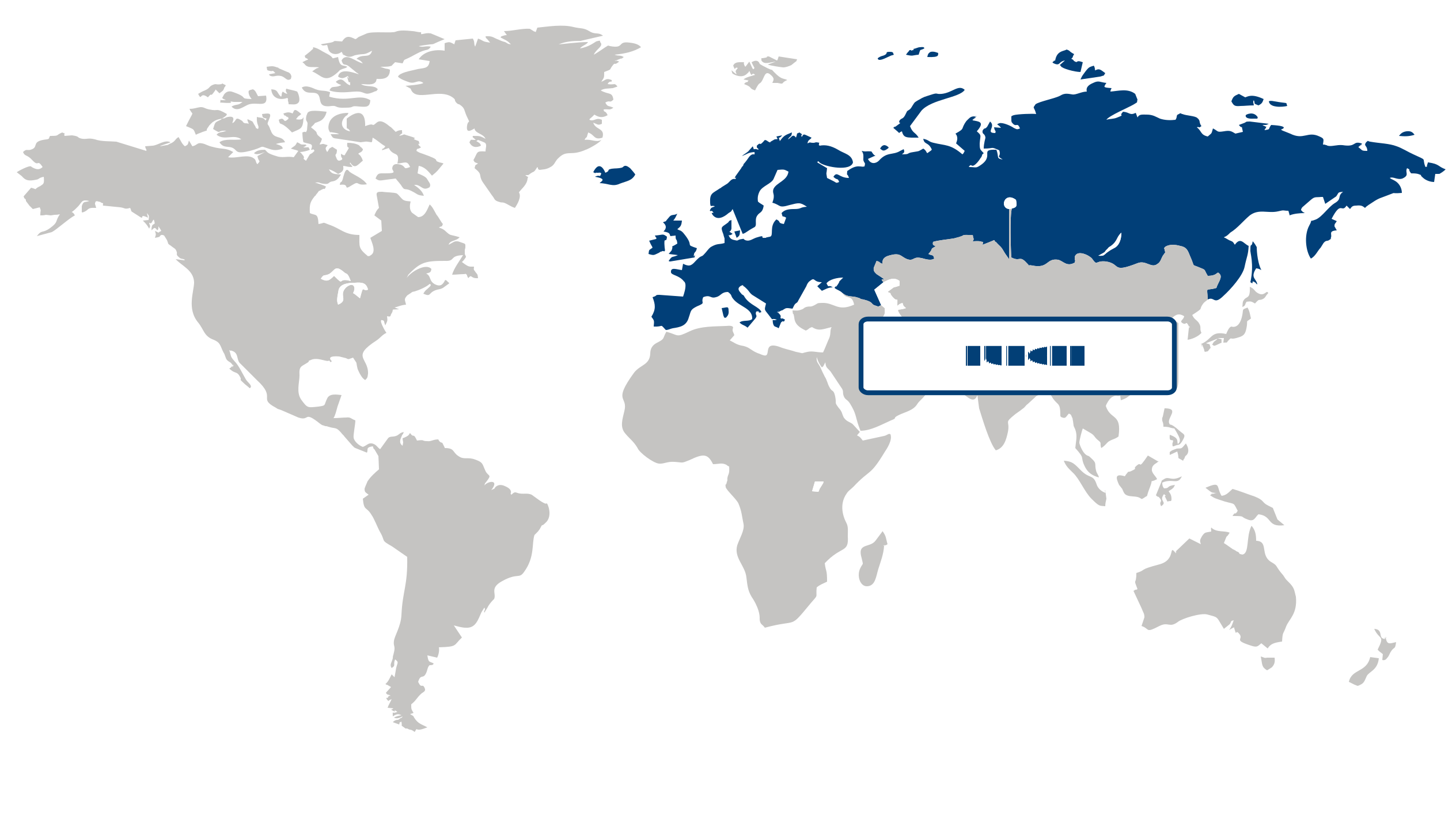
Largest Region
Europe
35.51% Market Share in 2026
Europe (Largest Region) vs Asia Pacific (Fastest-Growing Region)
Holding a 35.51% share of the geographic information system market in 2026, Europe maintained the largest regional position. Its leadership is supported by the widespread integration of geospatial technologies across public administration, urban planning, transportation, environmental monitoring, and infrastructure management. Strong digitalization initiatives and the emphasis on data-driven decision-making are encouraging broader use of geographic information systems, while established spatial data frameworks and continued investment in smart infrastructure strengthen regional demand.
Asia Pacific is positioned as the fastest-growing region, supported by rapid urban development, large-scale infrastructure projects, and increasing adoption of digital technologies across government and commercial sectors. Growing requirements for efficient land management, disaster response, transportation planning, and resource monitoring are accelerating the use of geospatial solutions. Expanding smart city initiatives, improvements in digital infrastructure, and rising investment in location-based analytics are expected to further support the region's growth in the geographic information system market.
Key Country Insights
The U.S. geographic information system market focuses on integrating spatial analytics across infrastructure, utilities, transportation, and public administration. Organizations continue expanding cloud-based GIS platforms to improve operational planning and data-driven decision-making.
Japan utilizes geographic information systems to strengthen disaster preparedness, urban planning, and infrastructure resilience. Investments prioritize accurate geospatial data integration and real-time visualization capabilities that improve emergency response coordination.
South Korea advances geographic information system adoption through smart city initiatives requiring integrated geospatial intelligence. Organizations increasingly deploy GIS solutions alongside IoT and digital infrastructure platforms to optimize municipal and transportation management.
Germany applies geographic information systems extensively in industrial planning, environmental management, and smart infrastructure projects. Demand increasingly supports platforms that integrate high-precision spatial data with engineering and asset management workflows.
France continues expanding geographic information system capabilities for environmental monitoring, land management, and public infrastructure projects. Market demand supports platforms that improve spatial analysis while simplifying collaboration across government and commercial users.
Italy applies geographic information systems to modernize transportation networks, utilities, and regional planning activities. Organizations increasingly value interoperable GIS platforms that enhance mapping accuracy and improve long-term infrastructure management.
Segment Leadership and Growth Trends
Devices Segment Analysis: Desktop (Largest Segment) vs Mobile (Fastest-Growing Segment)
Desktop devices accounted for the largest share of 58.78% in 2026 in the geographic information system market, supported by their suitability for complex spatial analysis, detailed mapping, data visualization, and professional GIS workflows. Organizations in planning, infrastructure, engineering, environmental management, and other data-intensive fields often require larger displays and substantial computing capabilities to process extensive geographic datasets. The continued need for sophisticated analytical functions and detailed geospatial visualization reinforces demand for desktop-based GIS environments.
Mobile devices are gaining momentum as organizations increasingly require location-based information and field data collection outside conventional office environments. Smartphones and tablets enable users to capture geographic information, access maps, update datasets, and communicate field observations in near real time. Growing adoption of mobile workforce practices and the need to connect field operations with centralized GIS platforms are supporting broader use of mobile GIS technologies.
Component Segment Analysis: Services (Largest & Fastest-Growing Segment)
Services held the largest share and are also the fastest-growing segment of the geographic information system market, accounting for 56.6% in 2026. GIS deployments increasingly require specialized implementation, integration, consulting, maintenance, and data-management expertise to align geospatial platforms with organizational workflows. As GIS applications become more sophisticated and increasingly integrated with cloud environments, enterprise systems, and real-time data sources, organizations are placing greater value on professional and managed services that support deployment and ongoing system performance.
| Report Segmentation | |||
| Segment | Sub-Segment | Largest Segment | Fastest Growing Segment |
|---|---|---|---|
| Devices | Desktop, Mobile | Desktop | Mobile |
| Component | Hardware, Software, Services | Services | Services |
| Usage | Surveying, Mapping, Navigation | Navigation | Surveying |
| Vertical | Utilities, Construction, Aerospace and Defense, Transportation and Logistics, Agriculture, Mining & Geology, Oil & Gas, Government, Others | Government | Construction |
 Read our Research Approach
Competitive Landscape and Market Positioning
Major players in the geographic information system market:
1. Esri Inc. (United States)
2. Autodesk Inc. (United States)
3. Hexagon AB (Sweden)
4. Bentley Systems Incorporated (United States)
5. Trimble Inc. (United States)
6. Topcon Corporation (Japan)
7. Pitney Bowes Inc. (United States)
8. SuperMap Software Co. Ltd. (China)
9. L3Harris Technologies Inc. (United States)
10. Autodesk Geospatial Solutions (United States)
Expanding use of spatial intelligence is transforming the geographic information system market across urban planning and infrastructure sectors. Integration of AI-driven mapping tools is improving geospatial accuracy and decision-making. Continuous innovation in data visualization is enhancing analytical capabilities. The geographic information system market is evolving through advanced spatial data processing technologies.
Industry Development/News
| Company Name | Date | Key Development |
|---|---|---|
| NV5 Global, Inc. | May-24 | NV5 Global, Inc. acquired GIS Solutions, Inc. to bolster its enterprise GIS service offerings. The integration expands the company’s technical capabilities in GIS application development and cloud-based database design, facilitating broader adoption of specialized geospatial technologies within their existing service portfolio and enhancing their market position in enterprise-level spatial data management. |
| Ceinsys Tech Ltd. | Jul-24 | Ceinsys Tech Ltd. expanded its geographic footprint and service capabilities in the U.S. market through the asset purchase of Virtual Tours, LLC. This strategic move strengthens the firm’s operational presence and enables the scale-up of its specialized GIS service offerings, positioning the company to better support geographically dispersed clients requiring advanced spatial data and visualization solutions. |
| Shell Kazakhstan | Apr-24 | Shell Kazakhstan formalized a memorandum of cooperation with the Ministry of Energy and National Geological Survey to digitize hydrocarbon subsurface data. This initiative leverages advanced geospatial technologies for resource exploration and sophisticated data management, marking a strategic shift toward digital subsurface intelligence to improve operational efficiency and decision-making in complex geological environments. |
| Placer.ai | Feb-24 | Placer.ai entered a strategic partnership with Esri to integrate consumer behavior analytics into geospatial intelligence workflows. By combining disparate datasets, the collaboration enables enterprise users to conduct more precise site selection and trade area analysis, creating a more robust framework for data-driven commercial real estate and retail location decision-making. |
| Avolve | Apr-24 | Avolve partnered with Esri to integrate its digital planning and permitting software with core GIS capabilities. This technical integration streamlines operational workflows for public agencies, allowing for the direct application of geospatial data within planning and permitting processes to enhance administrative efficiency, reduce process bottlenecks, and improve spatial decision-making across municipal operations. |
| Trimble Inc. | Apr-23 | Trimble Inc. launched the Trimble Unity AMS solution, an electric-based, GIS-centric platform designed for comprehensive asset infrastructure lifecycle management. By embedding GIS at the core of utility infrastructure operations, the solution enables more effective tracking, maintenance, and strategic planning, providing utility providers with a centralized, spatially informed environment for managing critical grid assets. |
| SkyWatch | Mar-24 | SkyWatch launched a Content Store integrated directly into Esri’s ArcGIS Online platform, simplifying the procurement and utilization of satellite imagery. By removing technical barriers to accessing diverse location-based data, this development enhances the interoperability of the GIS ecosystem and facilitates faster integration of high-resolution geospatial content into professional analysis and modeling workflows. |
| Madayn | Mar-24 | Madayn launched the "Explore" GIS platform to centralize data regarding industrial investment opportunities. The initiative represents a strategic investment in digital transformation, utilizing geospatial intelligence to provide stakeholders with clear, data-driven insights into site feasibility and investment planning, thereby increasing the transparency and accessibility of regional industrial land development and business planning data. |
| Duquesne Light Company | Mar-24 | Duquesne Light Company implemented a new outage management system incorporating advanced real-time geospatial data capabilities. The deployment significantly improves the utility's operational visibility, allowing for more precise network monitoring and streamlined service restoration processes by mapping grid disturbances against geospatial infrastructure data to optimize field crew deployment and overall system reliability. |
Why Choose Us
Specialized Expertise: Our team comprises industry experts with a deep understanding of your market segment. We bring specialized knowledge and experience that ensures our research and consulting services are tailored to your unique needs.
Customized Solutions: We understand that every client is different. That's why we offer customized research and consulting solutions designed specifically to address your challenges and capitalize on opportunities within your industry.
Proven Results: With a track record of successful projects and satisfied clients, we have demonstrated our ability to deliver tangible results. Our case studies and testimonials speak to our effectiveness in helping clients achieve their goals.
Cutting-Edge Methodologies: We leverage the latest methodologies and technologies to gather insights and drive informed decision-making. Our innovative approach ensures that you stay ahead of the curve and gain a competitive edge in your market.
Client-Centric Approach: Your satisfaction is our top priority. We prioritize open communication, responsiveness, and transparency to ensure that we not only meet but exceed your expectations at every stage of the engagement.
Continuous Innovation: We are committed to continuous improvement and staying at the forefront of our industry. Through ongoing learning, professional development, and investment in new technologies, we ensure that our services are always evolving to meet your evolving needs.
Value for Money: Our competitive pricing and flexible engagement models ensure that you get maximum value for your investment. We are committed to delivering high-quality results that help you achieve a strong return on your investment.
Select Licence Type